
| LASER SURVEY IN PIERLE |

Laser survey in Pierle.
The Pierle survey activity continues. What has already been anticipated in the previous article took place on 18 October with the use of a laser station. On that page we described the measurement operations carried out with the Total Station. We also said that a Laser Station would make the job much more accurate. For this reason the two graduate students Francesco Ranicchi and Besmira Braho , brought Prof. Fallavolita Federico , who brought with him one of the laser stations that the University of Bologna has at the Cesena site.
Accompanying the two undergraduates was also a third Architecture student, Giovannini Elisabetta Caterina , also about to graduate and interested in the use of the Laser Station for her thesis. Prof. Federico Fallavolita is a Researcher of Design at the Faculty of Architecture of Cesena, of the University of Bologna. Among other things, he deals with problems of representation and architectural relief. In particular he is interested in descriptive geometry revised on the basis of new IT tools.
The day of the Professor and his students started very early. The regulation of the University of Bologna provides that the Laser Stations, given the high value they have, cannot remain outside the faculty for more than one day. Students who intend to use it must find an accompanying teacher and put themselves on the waiting list. This is the process that Francesco and Besmira also followed.
The regulation also provides that before returning the station, the station must be emptied of all the measures, so that those who use it the next day will find it ready for use, with all free memory.
On the basis of this regulation, the day developed in the following way and our technicians had to: - Take the Laser from the faculty in Cesena, at the opening of the departments;
- Reach Pierle which is about 180 Km away;
- Carry out the surveys of the castle with the aim of making the greatest number of positions as the station is available for one day only;
- Return to the Faculty in Cesena, another 180 Km;
- Download the measurements by freeing the memory of the Laser Station;
- Return the instrument before the closing of the Departments.
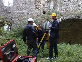
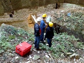
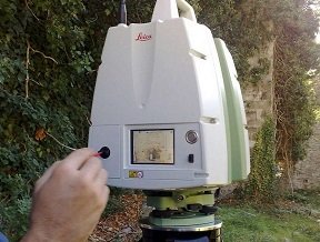
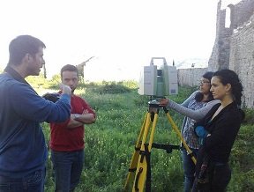
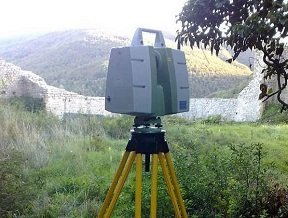
As soon as we arrived at the fortress, the Professor and the students immediately got busy. Based on an already established timetable, they began with the first placement of the laser station in the northernmost room. The operations foresee the `` leveling '' of the tripod, i.e. a stable and oriented positioning of the support that will hold the station during the measurement. Subsequently, the station is positioned and it is switched on.
During the start-up phase, which can last several minutes, the station checks, among other things, the quality of the positioning, informing the operators. If a location does not allow the station to properly arrange its optics, there will be a warning and the machine will not start.
After positioning and switching on the station, it is possible to pre-arrange the machine for measurement. All functions are accessible via a touch-screen and the station works as a computer or as a smart-phone. There are several applications through which you can access the machine settings or the files of the measurements already made.
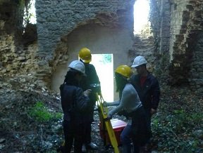
One of the stages that requires more experience is the choice of the position where to place the laser station. The measurement point must be such as to allow the illumination of the greatest number of details in the castle, but at the same time it must allow the various measurements made to be linked together. For this reason it is necessary that some points of the castle are measured several times in the day and from different placements, in order to then be able to recompose the whole castle on the computer..
Once placed and switched on, the station starts its measurement. Operators must move away from the station while it illuminates the subject in order not to shade the walls or soil the photographs. In fact, the machine in the survey phase performs two samples. The first through a laser beam that measures the distance and angle of the points and the second through a series of photographs. The station automatically superimposes the two reliefs restoring clouds of colored points based on the information extracted from the images themselves.
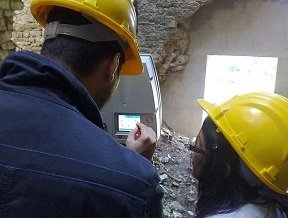
Once the measurement has been completed, it is possible to view what has been detected directly from the instrument LCD screen. All the photographs taken, in the measurement just finished, have already been merged into a single 360° panoramic image that can be navigated with the touch-pen. This view allows you to evaluate parameters such as brightness and exposure of images, in order to optimize the quality of the photographic recovery.
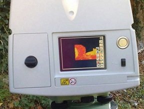
Through another application it is also possible to preview the measured point clouds. This representation is less intuitive than the photographic one, because the images have a representation in polar coordinates that is less easy to guess. One thing is certain, the points where the laser has not encountered obstacles within its range of 35 meters are black, because the measurement has failed.
Once the measurement is complete, the machine is switched off. A few minutes pass before the scanner switches off completely, after which it is carefully placed inside its box. The scanner is quite heavy and unwieldy, moreover its internal optics are very delicate. For this it must be moved off inside its container.
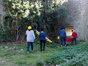
Choosing a new position, you start all over again. Stand positioning, leveling with knobs, fixing with locks, assembly of the station and ignition. But this time the professor decides that after six stations (placements) the students may be able to start a new measurement on their own. The latest recommendations are given and the students set the machine to start another measurement.<
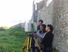
Some little uncertainty and under the supervione cost of the teacher, Besmira and Elisabetta try to start a new station. A small color calibration of the camera also needs to be done as the station is now located in Pierle's large courtyard and the ambient lighting has changed from the previous stations. Half of the courtyard is now in the shade while the rest is in full sun. The photos must be corrected in post-production.
However, regardless of any photographic consideration, the day was excellent from a meteorological point of view. For the third week of October, the weather has been too mild. The foggy morning gave way to a splendid sunny day that offered an almost ideal climate for surveying. The ''almost'' is related to the fact that on sunny days like today, the difference in brightness between shaded / sunny subjects will produce color variations as the point clouds overlap.
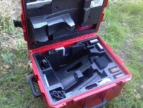
Here is a detail of the laser station box. This is a very important item. It is used to keep the station absolutely still during transport and to make it as immune to shaking as possible. The value of a station is linked to the goodness of its optics which is clearly based on the precision of its very expensive and delicate lens system.
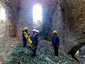
This photo shows the laser scanner while it detects the last station. We must hurry, because the station is about to light up while we are taking the photos. It is definitely not recommended to make the station optics coincide with that of my camera which would be irreparably burned. It is definitely the last station. It starts to get dark. Then the Professor and the students must return to Cesena.
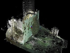
After a few weeks, the students sent in some screenshots that the post-production software made. In these virtual images the Rocca di Pierle is represented in the form of colored point clouds obtained by superimposing the measurements made on October 18th. As expected, the model shows that on the square in front of the entrance, the point clouds have different brightness because those made in the morning were in full sun. Very suggestive images.
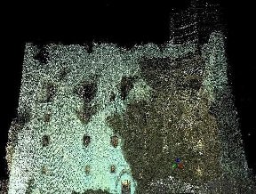
This virtual image shows the south facade of Pierle's keep. What looks like a photograph is instead a set of points that geometrically express Pierle's walls. On the left side of the photo, however, there is an increase in the density of the points, linked to a greater number of strokes made on the side of the tower.

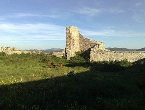
In the perspective view from above, the shape of the Castle of Pierle can be recognized once again. In these images, however, all the measures of the Rocca di Pierle are available and it is possible through their re-elaboration to design tailor-made interventions with the aim of saving the magnificent structure from its state of decay.
Again a great job guys.
Last update 21/02/2021
| 


